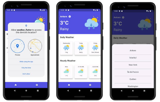
? weather_pack
A quick way to get access to weather conditions.
Resources
- folder
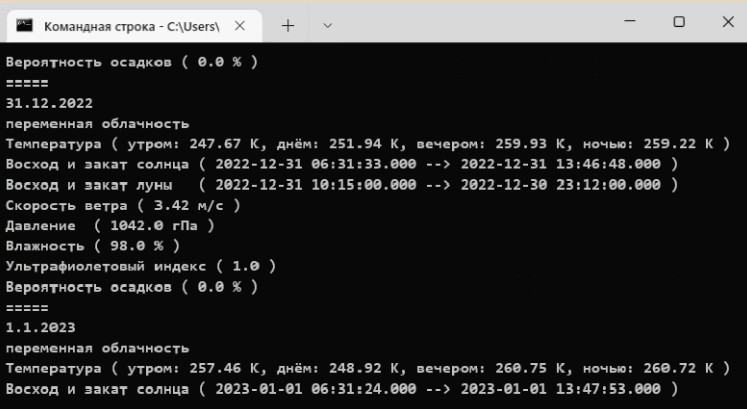
example. There is a simple example of how to use the basic functions of the package, as well as a console mini-application without using flutter

Feel free to suggest materials for inclusion in this list ^_~
Endpoints openweathermap.org
Let’s agree to designate Openweathermap as OWM.
The library uses the following site endpoints openweathermap.org:
| Endpoint or Path | A class or method that uses this endpoint | See more |
|---|---|---|
| api.openweathermap.org/data/2.5/weather | WeatherService.currentWeatherByLocation |
current |
| api.openweathermap.org/data/2.5/onecall | WeatherService.oneCallWeatherByLocation |
one-call-api |
| api.openweathermap.org/geo/1.0/direct | GeocodingService.getLocationByCityName |
geocoding-direct |
| api.openweathermap.org/geo/1.0/reverse | GeocodingService.getLocationByCoordinates |
geocoding-reverse |
Table of Contents
- ? weather_pack
- Resources
- Endpoints openweathermap.org
- Table of Contents
- Installing
- Getting Started
- Usage weather service
- Usage geocoding service
- Usage units measure
- Usage weather icons
- API key testing
- Features in development
- Additional information
Installing
- Add dependency to your
pubspec.yaml:dependencies: weather_pack: <latest_version>
- Run the command:
flutter pub get - Use in your code:
import 'package:weather_pack/weather_pack.dart';
Getting Started
The easiest way to get the current weather:
Future<void> main() async {
  const api = 'YOUR_APIKEY'; // TODO: change to your Openweathermap APIkey
  final wService = WeatherService(api);

  // get the current weather in Amsterdam
  final WeatherCurrent currently = await wService.currentWeatherByLocation(
      latitude: 52.374, longitude: 4.88969);

  print(currently);
}
You can also change the request language:
final lang = WeatherLanguage.arabic;

final wService = WeatherService(api, language: lang);
Supported languages: (Click to open)
- Afrikaans
- Albanian
- Arabic
- Azerbaijani
- Bulgarian
- Catalan
- Czech
- Danish
- German
- Greek
- English
- Basque
- Persian
- Farsi
- Finnish
- French
- Galician
- Hebrew
- Hindi
- Croatian
- Hungarian
- Indonesian
- Italian
- Japanese
- Korean
- Latvian
- Latvian
- Macedonian
- Norwegian
- Dutch
- Polish
- Portuguese
- Português Brasil
- Romanian
- Russian
- Swedish
- Slovak
- Slovenian
- Spanish
- Serbian
- Thai
- Turkish
- Ukrainian
- Vietnamese
- Chinese Simplified
- Chinese Traditional
- Zulu
According to OWM service (See more):
You can use the
langparameter to get the output in your language.Translation is applied for the
city nameanddescriptionfields.
Usage weather service
Now there are two weather models – WeatherCurrent and WeatherOneCall.
WeatherOneCall includes:
WeatherCurrentList<WeatherHourly>List<WeatherMinutely>List<WeatherDaily>List<WeatherAlert>
How to use?
You can get the weather in the following way:
final WeatherCurrent current = await wService
    .currentWeatherByLocation(latitude: 52.374, longitude: 4.88969);

final WeatherOneCall onecall = await wService
    .oneCallWeatherByLocation(latitude: 52.374, longitude: 4.88969);
Why do you only use the weather search by coordinates?
According to the website OWM:
Please use Geocoder API if you need automatic convert city names and zip-codes to geo coordinates and the other way around.
Please note that built-in geocoder has been deprecated. Although it is still available for use, bug fixing and updates are no longer available for this functionality.
Usage geocoding service
GeocodingService is a service for easy location search when working with geographical names
and coordinates. Supports both the direct and reverse methods:
- Direct geocoding converts the specified name of a location or zip/post code into the exact geographical coordinates;
- Reverse geocoding converts the geographical coordinates into the names of the nearby locations;
You can find out more at this link: Geocoding API OpenWeather
How to use?
Create GeocodingService in the following way:
final String cityName = 'suggested location name';
final String apiKey = 'your api key for OWM';

final GeocodingService gService = GeocodingService(apiKey);
To find using place names use direct geocoding:
final List<PlaceGeocode> places = await gService.getLocationByCityName(cityName);
or use reverse geocoding
final List<PlaceGeocode> places = await gService.getLocationByCoordinates(latitude: 52.374, longitude: 4.88969);
Usage units measure
By default, all weather models, e.g. WeatherCurrent, have measurable values of type double.
To display the data in a convenient format, it is necessary use the conversion method value
or valueToString:
void worksTempUnits({
  double temp = 270.78, // ex. received from [WeatherCurrent.temp]
  int precision = 3,
  Temp unitsMeasure = Temp.celsius,
}) {
  // The default temperature is measured in Kelvin of the `double` type.
  // We need the temperature to be displayed in Celsius to 3 decimal places

  print(unitsMeasure.value(temp, precision)); // `-2.37` type `double`
  print(unitsMeasure.valueToString(temp, precision)); // `-2.370` type `String`

  // if precision is 0:
  print(unitsMeasure.value(temp, 0)); // `-2.0` type `double`
  print(unitsMeasure.valueToString(temp, 0)); // `-2` type `String`
}
By and large, the valueToString() method is needed to display correctly in ui,
and the value() method is for accurate calculations.
There are several units of measurement:
| Units of measure | Class | Supported units | Conversion |
|---|---|---|---|
| Temperature | Temp |
kelvin, celsius, fahrenheit | + |
| Speed | Speed |
ms, mph, kph | + |
| Pressure | Pressure |
hectoPa, mbar, mmHg, kPa, atm, inHg | + |
| Cardinal points | SideOfTheWorld |
n, ne, e, se, s, sw, w, nw | +(another) |
? Tip: The SideOfTheWorld enum contains a static method fromDegrees() for converting degrees
to cardinal directions.
Usage weather icons
You can use weather icons provided by the OWM service. See more about weather conditions.
Icons are stored locally in this package at the path assets/weather_icons/.
They are ordered according to Declaring resolution-aware image assets.
This reflects the following correspondences:
100*100 - in default(implied resolution @1)
200x200 - @2
300x300 - @3
400x400 - @4
with the preservation of image quality.
How to use?
Get the weather icon in a safe way:
Image getWeatherIcon(String weatherIcon) {
  return Image.asset(
    ImagePathWeather.getPathWeatherIcon(weatherIcon),
    filterQuality: FilterQuality.high, // optional
    package: ImagePathWeather.packageName,
  );
}
or to process it completely by hand:
Widget getWeatherIcon(WeatherCurrent weather) {
  return Image.asset(
    'assets/weather_icons/${weather.weatherIcon}.png', // icon path
    package: 'weather_pack', // name package
    filterQuality: FilterQuality.high, // optional
    errorBuilder: (c, e, s) => Text(e), // will return the widget in case of an error
  );
}
By and large, you can use the best quality regardless of platform resolution by specifying @4 to path:
'assets/weather_icons/@4/$weatherIcon.png'
API key testing
It is possible to test the API key.
To do this, the OWMApiTest class has a method isCorrectApiKey():
void worksTestedAPIkey({
  String testedAPIkey = 'Your_key',
}) async {

  // If the key is correct, it will return `true`
  final bool isCorrect = await OWMApiTest().isCorrectApiKey(testedAPIkey);
}
Features in development
- Getting weather by location name (built-in geocoding).
Additional information
Made with ❤️. Enjoy it!